
An oppressively hot and humid air mass will increase energy demand in southeast Qld on Monday.
A very hot air mass will sit over the southern half of Qld on Monday, with temperatures likely to reach the mid-40s in the state’s southwest and the mid-to-high 30s in the southeast, including Brisbane.
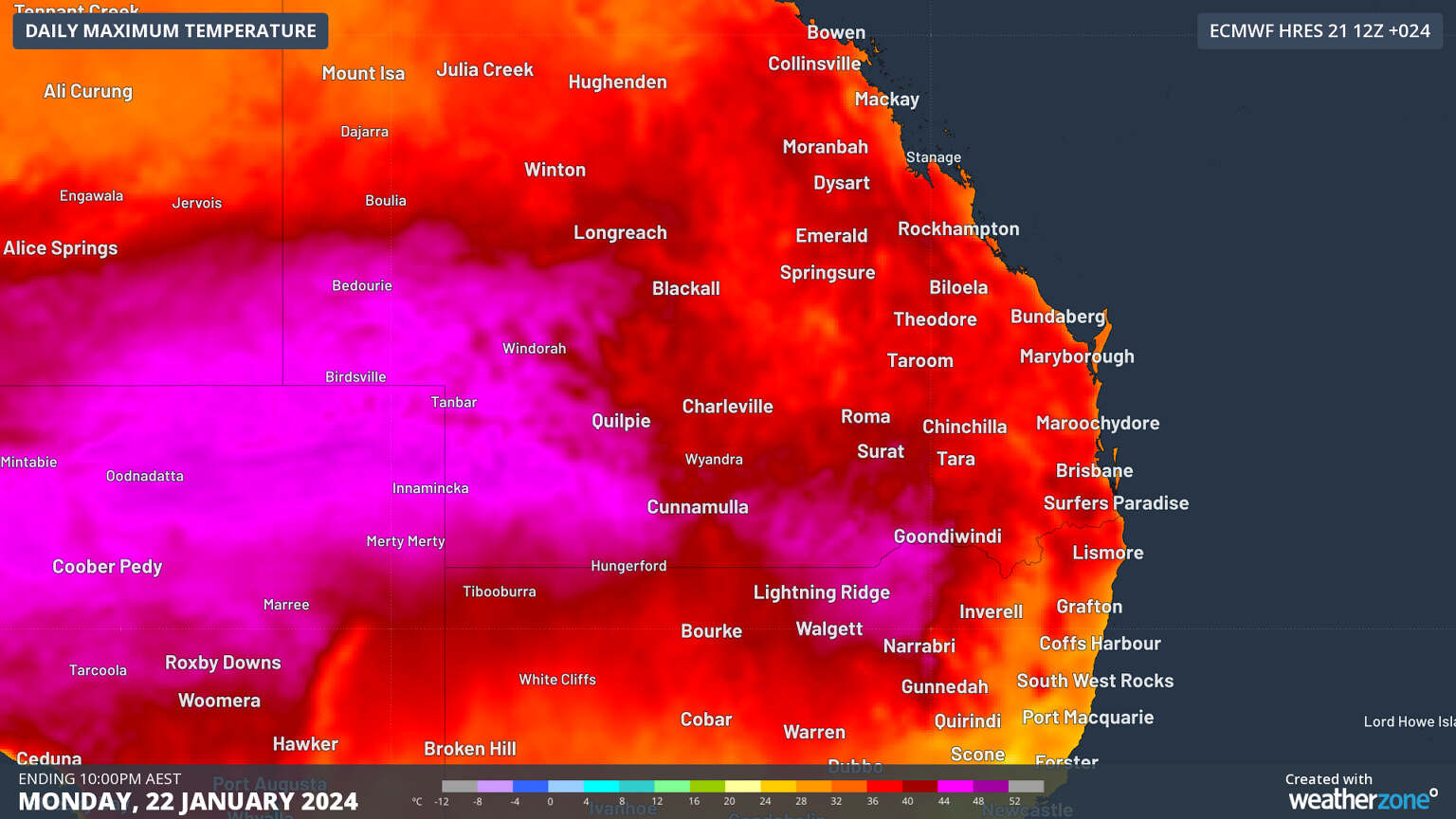
Image: Maximum temperature forecast for Monday, January 22, according to the ECMWF model.
Unfortunately for anyone living in southeast Qld, Monday’s heat will be exacerbated by high humidity, which will make the air temperature feel around 4 to 8ºC warmer than it is.
At 10:20am AEST on Monday, the temperature in Brisbane felt like 40.5°C, despite the temperature reaching only 34°C. This sweltering ‘feels like’ temperature was due to excessive levels of water vapour in the atmosphere, with a dew point of nearly 26ºC at the time.
The dew point is the temperature to which air must be cooled to achieve a relative humidity of 100%, or saturation of moisture in the atmosphere, at which point condensation will occur. The higher the dew point, the greater the amount of moisture in the atmosphere, which makes it more difficult for human bodies to cool down through the evaporation of sweat.
Below is a guide for how different dew point temperatures would make you feel if you were accustomed to Australia’s sub-tropical climate:
>24ºC – Oppressive, uncomfortable for most, possible heat stress issues
- 20-24ºC – Muggy and quite uncomfortable
- 15-20ºC – Starting to feel muggy, though still comfortable for most
- 10-15ºC – Comfortable 5-10ºC – Dry
- < 5ºC – Very dry
The map below shows the high dew points forecast over the region on Monday afternoon.
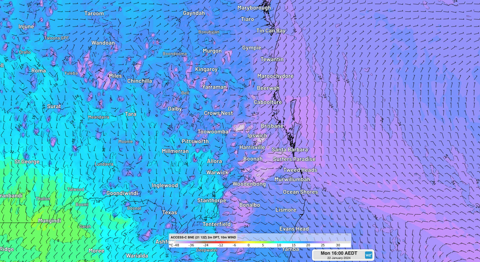
Image: Dewpoint and wind forecast at 3pm AEST, according to ACCESS-C
The ‘feels like’ temperature in parts of Brisbane should reach the high 40’s and in some areas could possibly hit 50°C on Monday afternoon.
According to Watt Clarity, the Brisbane area could see an all-time maximum energy demand record set in response to this heat and humidity in the late afternoon.
Afternoon thunderstorm activity is also possible in western Brisbane, which could increase cloud cover and reduce the performance of rooftop solar in the region. This could add even more pressure on the energy grid.
Fortunately, a southerly change that is moving up the northern NSW coast on Monday morning will make its way up to Brisbane by the early evening.
This southerly is expected to arrive in Brisbane around 5:30-6:30pm AEST, bringing relief from the heat and humidity as it sweeps through the city.
The temperature in Brisbane will drop significantly behind this change and should reduce the stress on the energy grid dramatically.
This article was originally published on WeatherZone, reproduced here with permission.
About our Guest Author
 |
Ashleigh Lange is a Head Communications Meteorologist at Weatherzone.
Weatherzone, a DTN company, is Australia’s largest private weather service and was established in 1998. Their team of highly qualified meteorologists understands the effect the weather has on the day to day operations of businesses of all kinds. They also run Australia’s most popular consumer weather website and mobile app. Weatherzone provides market-leading weather insights to more than five million Australians and over 15 industries, including energy, mining, agriculture, ports, aviation, retail, insurance, broadcast media and digital media. You can find Weatherzone and Ashleigh Lange on LinkedIn. |
Leave a comment