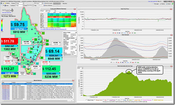
NEM-wide wind production peaked above 3,000MW on Wednesday evening 17th April 2024 – as captured this morning in this snapshot from NEMwatch at 09:10 (NEM time):
That’s several days earlier than we noted Tuesday when we wrote that the ‘NEM-wide wind lull stretches extends to a full week (Tue 16th April 2024), and has another week to go!’.
Changing AEMO forecasts
I’d noted that the forecast had surprised on the upside in this article yesterday afternoon, and what happened last night was stronger than was forecast a few hours earlier, on Wednesday afternoon.
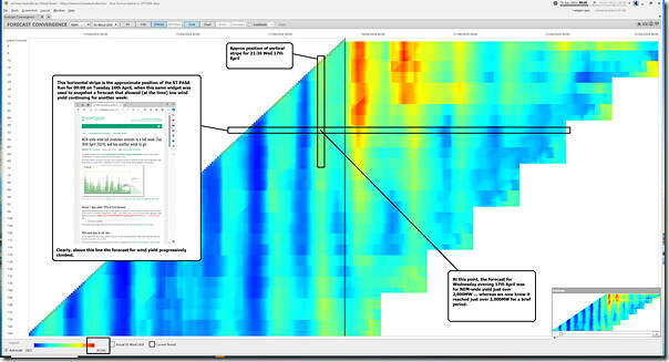
Thankfully with the ‘Forecast Convergence’ widget in ez2view, we can ‘look up a vertical’ to view ‘that other dimension of time’ … such as in this view of NEM-wide UIGF for Wind back a week and forward a week, snapped at 09:20:
I’ve annotated with a few key points. Remember to click on the image to open in larger screen view.
Looking up the red verticals, it appears that Thursday afternoon and Friday afternoon we might see yields around 4,000MW on a NEM-wide basis (barring economic curtailment and/or network curtailment, of course). If so, this would be about half of the current long-term maximum.
Changing underlying weather conditions?
Reaching out to WattClarity readers who are meteorologically trained to see if there’s something written that might help explain the changing nature of these forecasts?
PS1 comment by Christian Werner at Global Weather Climate Analytics
Over on LinkedIn here, Christian Werner wrote the following, in response to this request:
‘Thanks Paul McArdle for the update.
Forecasts are always changing and what we prefer is that there is some consistency in the forecast updates (to comment here on the exact details to why and how forecasts are changing is outside the scope here). From the forecast data we look at it all made sense that we should see a wind generation increase in TAS and VIC at first, driven by the approaching cold front. This was already known for a few days. Due to the high pressure frontolytic characteristics the cold front will decay and we should see a widening of the isobars again and with it a decrease in wind generation. Complicating factor is a semi-persistent trough.
Further down the track wind generation should pick up again as the SPV is edging closer to Australia. Not sure what AEMO is using for the wind generation forecasts but based on what was reported here there is certainly room for improvements. ‘
PS2 from Weatherzone
Also in response to this request, Weatherzone contributed the article ‘Generation gone with the wind’ on WattClarity.
Surprised on the upside (this time)
On this occasion, the wind yield seems to be surprising on the upside, compared to earlier forecasts.
But that’s also a timely reminder that it also does surprise on the low-side. I wonder whether each is equally likely (or not?).


Leave a comment