For the first time since the fateful Black Summer, the mercury has reached 47°C in Victoria, as an intense heatwave bakes large parts of eastern Australia including a big chunk of our southernmost mainland state.
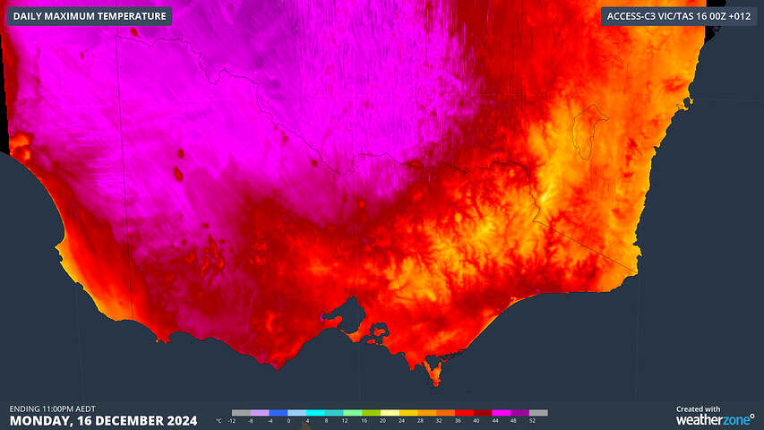
- Shortly after 2pm, the mercury peaked at 47.1°C at Walpeup, a tiny town in the Mallee region in the state’s northwest with a population of around 150.
- As of 3pm Monday (AEDT), temps had reached 44°C or higher at several locations in the Mallee and Wimmera districts including Mildura (45.1°C), Hopetoun Airport (45.4°C), Swan Hill (45°C) and Horsham (44°C).
- Even Victoria’s southern coastline has not been spared today’s extreme heat, with Warrnambool reaching 41.2°C just after 1pm before rapidly shedding more than 10 degrees within half an hour as a cooler west-southwesterly change pushed through.

Image: Forecast maximum temperatures for Victoria and nearby areas on Monday, December 16. Source: Weatherzone
The map below shows the forecast maximums for this Monday with pink areas equating to a top of 44°C or higher, and it has proven remarkably accurate.

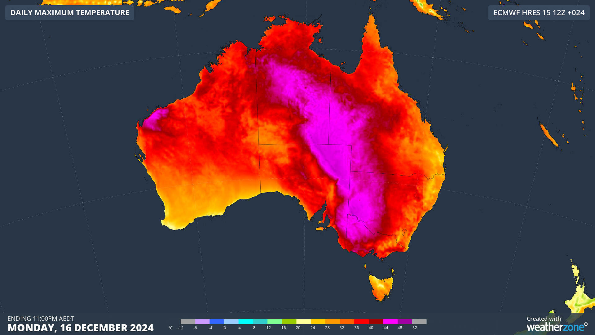
Image: Forecast maximums across Australia on Monday, December 16, 2024.
As the map shows, it’s not just Victoria which has seen extreme heat this Monday. Sizzling temps in the vicinity of 45°C up to 3pm AEDT have also been recorded in:
- Eastern SA (Renmark 46.5°C, Lameroo 44.9°C)
- Western NSW (Wilcannia 45.3°C, Mulurulu 45.2°C, Ivanhoe 45.2°C)
- Southwest Qld (Birdsville 45.5°C)
- Northwest Qld (Urandangi 46°C)
- Southeastern parts of the NT (Jervois 45.4°C)
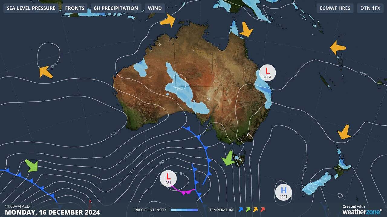
The extreme heat has been caused by northerly winds circulating around a high pressure system centred over the Tasman Sea.
These winds have funnelled hot air from the interior of the continent southwards, and since the weather systems have been relatively slow-moving in recent days, plenty of hot air has been allowed to build up.

Image: Synoptic chart for Australia on Monday, December 16, 2024.
As we progress through Monday afternoon, the temperature is yet to reach 40°C in Melbourne, with 38.1°C recorded just before 3pm en route to a predicted maximum of 41°C. Geelong reached 40.7°C not long after 2pm.
That cooler change that whipped through Warrnambool just after 1pm should reach Melbourne around twilight.
Meanwhile the heatwave will continue into Tuesday in eastern NSW, with temps reaching as high as 41°C or 42°C in the outer western suburbs of Sydney and in the towns of the lower Hunter Valley, just west of Newcastle.
This article was originally posted on Weatherzone and has been republished here with permission.
About our Guest Author
 |
Ant Sharwood is a Journalist at Weatherzone.
Weatherzone, a DTN company, is Australia’s largest private weather service and was established in 1998. Their team of highly qualified meteorologists understands the effect the weather has on the day to day operations of businesses of all kinds. They also run Australia’s most popular consumer weather website and mobile app. Weatherzone provides market-leading weather insights to more than five million Australians and over 15 industries, including energy, mining, agriculture, ports, aviation, retail, insurance, broadcast media and digital media. You can find Weatherzone and Ant Sharwood on LinkedIn. |


Leave a comment