The recent bout of strong winds lashing the southern states may have been supported by a case of sudden stratospheric warming.
Warming in the stratosphere over Antarctica can drive the Southern Ocean westerly wind belt towards the Equator. This typically means stronger winds to southern Australia. And this means greater potential for wind-powered electricity generation.
Stratospheric warming in July 2024
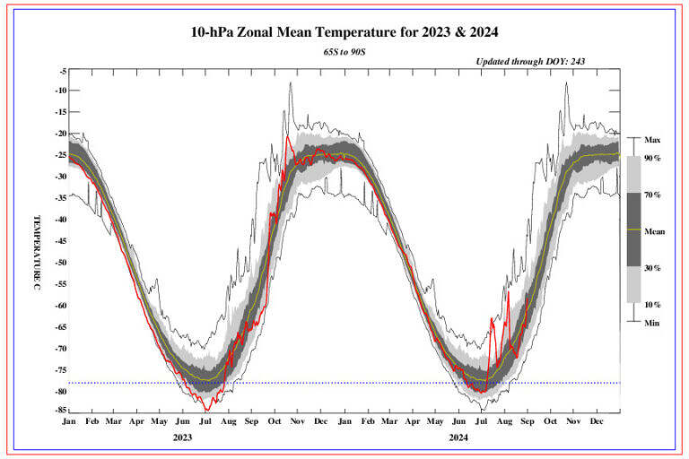
Back about 5 weeks ago on the 27th July, the ABC reported that around early-July “the temperature more than 20 kilometres above the east Antarctic coastline suddenly warmed by about 50 degrees Celsius in a week”.
This represented a case of Sudden Stratospheric Warming (SSW), an unusual situation for the southern hemisphere.
The ABC article went on to explain that typically “this sudden change over the stratosphere will then filter down and disrupt the troposphere (the layer of atmosphere where weather occurs), which can result in prolonged spells of extreme weather for weeks.”
A Weatherzone article explained how SSW events can influence winds in Australia. It described a sequence of “domino” effects where, some weeks after the warming event has happened in the troposphere, the warming event can end up altering the position of the surface-level westerly winds that typically blow between Antarctica and Australia.
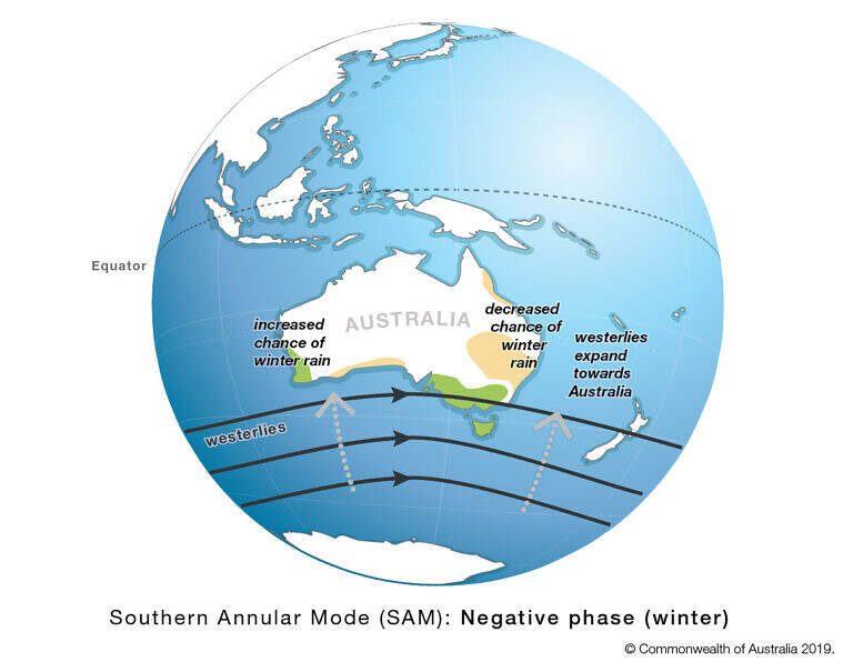
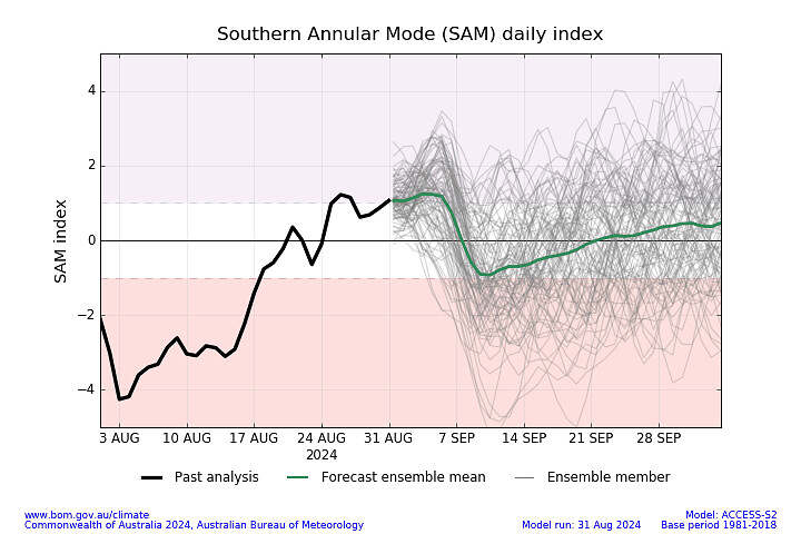
The altered position of the westerlies tends to be further north (towards the Equator). It is measured by an index known as the Southern Annular Mode (SAM). When these westerly airstreams are further north the SAM is in a negative phase.
For us in the NEM, Weatherzone note in that same article that a negative SAM typically brings:
- More cold fronts and low-pressure systems over southern Australia
- Increased rainfall and snow potential in southwest and southeast Australia
- Reduced rainfall in parts of eastern Australia
- Stronger winds in the southern half of Australia
I’ve bolded the last point for emphasis as that’s exactly what we’ve experienced over the last days and weeks in VIC, SA and TAS!
Readers may recall related coverage of the windy weather at WattClarity including:
- It could be a high wind yield week ahead in the NEM?
- Wild winds in TAS drive aggregate instantaneous Wind Farm capacity factor close to 100% and
- High wind yield in recent days: but *not* a new all-time record
Here’s a visual depiction of a negative SAM from the Bureau of Meteorology, showing the westerly wind belt sitting further north.

Source: Australian Bureau of Meteorology
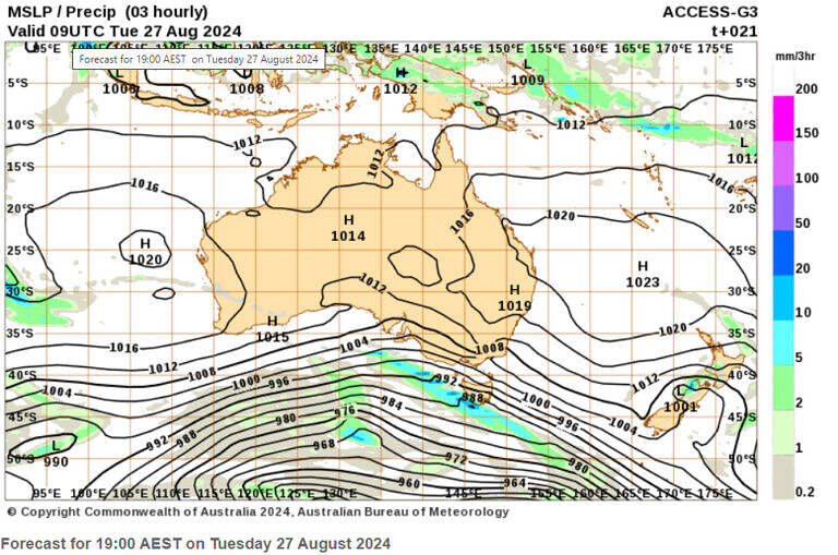
And here is a chart of mean sea-level pressure isobars, and forecast rainfall, covering Tuesday 27th August 2024.

Source: Australian Bureau of Meteorology
Since early July there has been a second warming event
The ABC article from July included a chart of Zonal Mean Temperature for the Antarctic troposphere that showed the SSW event of early July as a spike. The following update to that same analysis chart (NOAA’s climate prediction Center) includes that period – July 2024 temperatures eclipsed the max line at their peak.
What’s also interesting is the second spike in warming early in August, peaking well above the 90th percentile level. This was forecast in in the outlooks from mid-July.

Source: NOAA Climate Prediction Center
Returning to a neutral SAM… for now
As at 17 August, the Southern Annular Mode had indeed been negative. It had been negative since 21st July. In the latest update (as at 31st August) it had returned to a more neutral setting.

Right now, outside my window, its hailing. The wild weather continues!


Thanks for this Linton, fascinating!
You’re probably already aware, but Wattclarity had an article on the SAM back in 2017 when we had possibly the worst wind drought of the last decade. https://wattclarity.com.au/articles/2017/07/the-southern-annular-mode-sam-contributes-to-recent-wind-drought/
Thanks David! Another great resource to be reminded of – a positive SAM in that case. The state of the SAM is definitely one to monitor.