Paul McArdle wrote this article yesterday about the AEMO’s notice of possible extreme temperatures next week for Adelaide, Melbourne and Sydney, so I decided to have a closer look, using data we have access to at MetraWeather.
A key aspect of the forecasts for next week’s heat event is the large uncertainty that still surrounds these forecasts. While many forecasts predict temperatures to reach the mid-to-high 30s for Melbourne and low 40s for Adelaide, there are a significant handful of possible outcomes still on the table that could see both cities simultaneously exceeding 40 degrees, and in some circumstances by a significant amount.
Take a look at the two scatterplots below, plotting all daily maximum temperatures from 1 January 1981 to 31 December 2018:
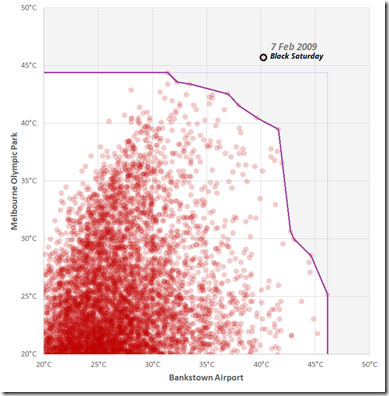
(a) Above, we plot Melbourne vs. Bankstown.
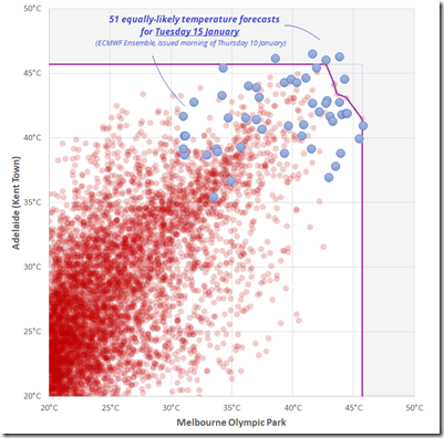
(b) Underneath, we have Adelaide vs. Melbourne.
Also included on these scatterplots is a line called the Pareto Frontier. This line is one way of describing the highest combination of heat observed in the historical data. Anything above this line could arguably be called record heat, since:
(a) it would either exceed the maximum value recorded at Location A and/or B, or
(b) it would exceed the highest combination of heat ever seen with respect to similar combinations of heat.
In other words, this line takes into consideration that extreme heat at one location can often limit the ability for another city extreme heat at the same time, and so sub-record values at both locations may still be unprecedented when viewed in combination.
Looking first at the scatterplot at the top:
- Both Melbourne and Bankstown have risen into the low-to-mid 40s on several occasions since the 1980s. However, these two cities have difficulty in reaching extreme temperature values at the same time. The Pareto Frontier reflects this, as it carves away a large region of possible heat combinations. In fact, while both cities somewhat regularly exceeded the 40-degree mark, there is only one day in the 38-year dataset where Melbourne and Bankstown were both above the 40-degree mark at the same time: Black Saturday, (7 Feb 2009). Purposefully excluding this day from the Pareto Frontier line, it becomes obvious just how exceptional this heat event was for southeastern Australia.
On the second scatterplot:
- Adelaide and Melbourne heat is more correlated to one another, and thus the Pareto Frontier carves away a much smaller corner of the plot. However, while both cities have reached above the 45-degree mark since 1981, it was never at the same time. Thus, if both locations were to hit 44 to 45 degrees simultaneously next week, neither would break their individual records, but it would be a new frontier of extreme heat. But the question bears asking: Is that kind of heat combination possible next week?
- Also shown on this graph are 51 equally-likely predictions of Adelaide and Melbourne’s maximum temperatures on Tuesday 15 January 2019, as predicted by the 51 individual model members of the ECMWF Ensemble model. While Monday is expected to see hot temperatures, the most extreme solutions are focussed on Tuesday. Looking at these 51 forecasts, there are a few that suggest record heat for Adelaide or Melbourne. There are also several that approach the Pareto Frontier line, which would imply Melbourne-Adelaide combination heat that would be nearly unprecedented. While we may not necessarily see a record broken at either individual location, there is a significant chance that near-record conditions could occur when considering the two locations as a pair.
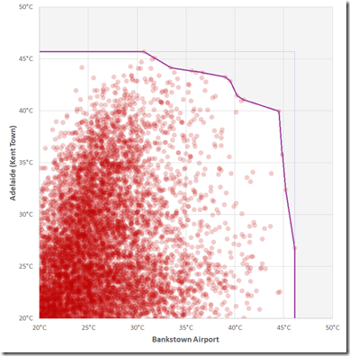
Lastly, here is the same scatterplot for the combination of Adelaide and Bankstown.
Somewhat counterintuitively, Sydney heat actually has a stronger correlation with Adelaide heat than with Melbourne. While the Sydney region is expected to see hot temperatures through the mid-week, the most strenuous temperatures are expected to be in Adelaide and Melbourne, both individually and in combination.
About our Guest Author
| Rob Davis is a Meteorologist who has worked with MetraWeather since December 2013 – and prior to that for many years with The Weather Network.You can find Rob on LinkedIn here.
MetraWeather is a world leader in the supply of weather data visualisation and automated prediction technology solutions to energy, broadcasting, retail and other industry clients around the globe. MetraWeather works with clients throughout the energy supply chain, providing specialised software, dependable high-quality forecasts and observational data designed to give customers the essential insights necessary for them to make timely and effective business and trading decisions. |


Leave a comment