Earlier this year destructive thunderstorms and winds equivalent to a category two cyclone lashed Victoria, bending towers and toppling trees and poles. So, how can thunderstorms damage energy infrastructure, and are these events getting worse?
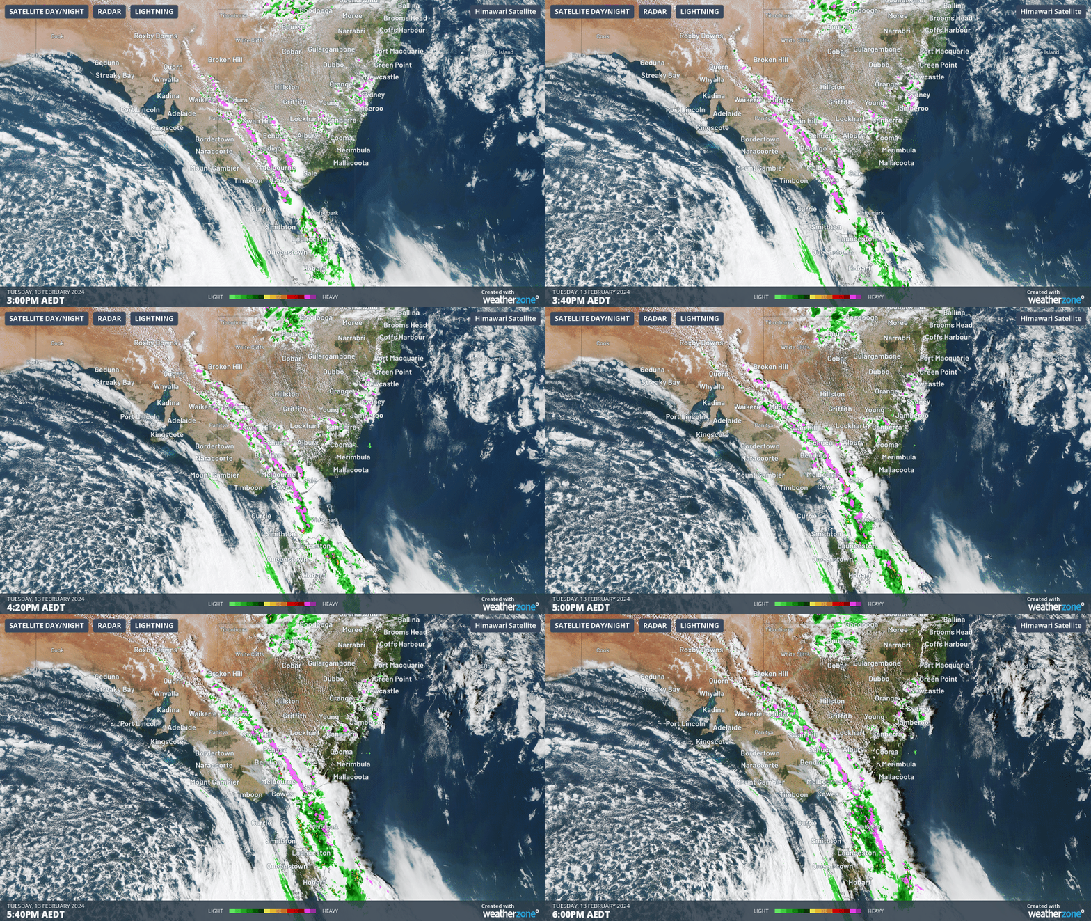
This event occurred during mid-February 2024, when a strong cold front generated severe thunderstorms and localised wind gusts of 130km/h after a prolonged period of extreme heat. The image below shows a squall line around 1,500km long causing lightning across four states in February.

Image: Himawari-9 satellite image, lightning and radar on Tuesday, February 13 at 3pm AEDT.
The destructive winds were caused by microbursts, which bent towers and toppled trees and poles in Vic, leaving thousands without power.
[Image removed from AAP 2025-02-12]
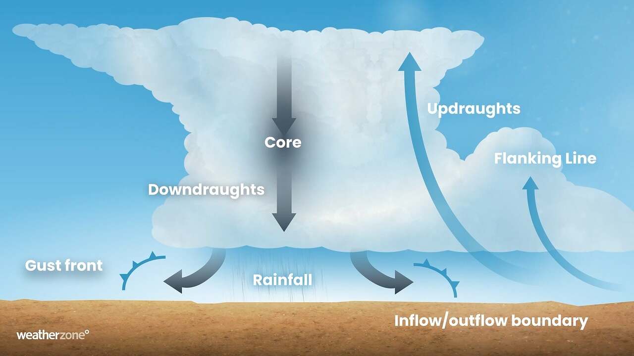
Microbursts are a localised column of sinking air (downdraft) within a thunderstorm and is usually less than 4km wide. The cold, heavy air within this downdraft descends rapidly to the surface and then spreads out in all directions as it hits the ground. The image below shows how wind gusts are produced in thunderstorms.

Microbursts can be destructive and cause wind gusts above 100 km/h, which can be a risk for power infrastructure. The force applied to the structure is roughly proportional to the speed squared.
Fierce wind gusts from thunderstorms can:
- Knock down trees, which can fall onto power lines
- Topple poles
- Knock out transmission towers.
Microbursts typically occur during the warmer months of the year and, unfortunately, they can develop rapidly and last for only a short period of time, making them difficult to predict and warn communities about.
Have these thunderstorm events become more severe in Victoria?
The severe thunderstorm season across southern Australia occurs during the warmer months of the year, between November and April.
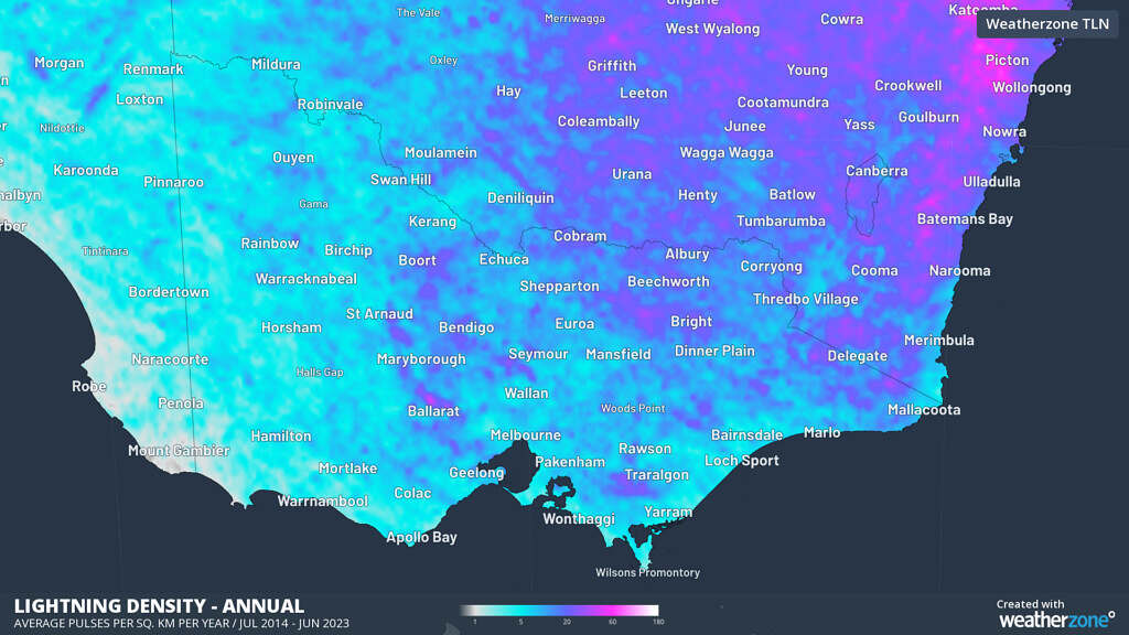
While thunderstorms are more common across northern Australia, Qld, and NSW, they do occur frequently in the summer months. The map below shows the annual average lightning density in Vic between July 2014 and June 2023, with the most lightning occurring in the northeast high country each year.

Image: Weatherzone’s Total Lightning Network Annual lightning density mean between July 2014 and June 2023.
You can see in the map above that lightning is common to the north of Ballarat near Learmonth and Miners Rest, with the region seeing 37.7 pulses per year. The high country near Benalla and Whitfield recorded an average of 28.1 pulses, Thorpdale in Gippsland saw 24.5 pulses, and Melbourne only 8.2 pulses per year.
Research has shown that the warming climate is increasing the risk of heatwaves and bushfires, which can impact energy infrastructure. Unfortunately, it is unknown how global warming will affect thunderstorms and their associated destructive winds. To research climate change’s impact on thunderstorms, we would need quality data that dates back well into history. Unfortunately, detecting lightning is a fairly new phenomena, so a solid climate base to compare data to is not currently existent.
According to the University of Melbourne researchers and Watt Clarity, ‘The evidence we do have suggests continued climate change may potentially increase the risk of extreme winds from thunderstorms. This is partly due to more moist and unstable air, which are essential for thunderstorms to form. We think these conditions could occur more often with climate change, in part because warmer air can hold more moisture.’
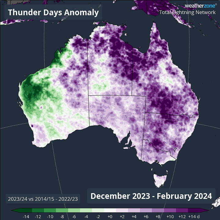
Indeed, much of Australia had an unusually stormy summer 2023/24, with Melbourne, Canberra and Brisbane all seeing 5 to 6 extra storm days a season. The map below shows that an unusually high number of thunder days were seen over most of Qld, NSW, SA, Vic, the ACT and Tas during the summer of 2023/24 compared to the average of the most recent nine years.

Image: Thunder day anomalies for summer 2023-24 versus the average thunder days for the nation’s nine most recent summers (2014/15 to 2022/23).
This article was originally published on WeatherZone, reproduced here with permission.
About our Guest Author
 |
Ashleigh Madden is a Head Communications Meteorologist at Weatherzone.
Weatherzone, a DTN company, is Australia’s largest private weather service and was established in 1998. Their team of highly qualified meteorologists understands the effect the weather has on the day to day operations of businesses of all kinds. They also run Australia’s most popular consumer weather website and mobile app. Weatherzone provides market-leading weather insights to more than five million Australians and over 15 industries, including energy, mining, agriculture, ports, aviation, retail, insurance, broadcast media and digital media. You can find Weatherzone and Ashleigh Madden on LinkedIn. |


Be the first to comment on "How severe thunderstorms impact energy infrastructure"